Sunday, May 24, 2015

Moab -- WOW


Day 37   May 12, 2015

Because we have heard from the weather forecasters that the wind will be picking up today we wanted to get an early start.  We did “good” by doing this. 
The only strong gusty wind we hit was about 5 miles from Moab.  Since the winds did not give us much of an issue, we were lucky enough to enjoy some beautiful scenery, as we climbed up and down some really tough “hills”.   The area along I-70 from I-15 to the Moab turn off was absolutely gorgeous.  At one point we read a sign that said that there will be no services available for 110 miles.  I thought that this wasn’t possible on an interstate highway at this time.  Boy was I wrong.  Through the some of the toughest hills that we have encountered, there wasn’t any help if we needed it.  In fact, as we came down one of the steepest and longest hills, the tractor trailer behind me hit a curb and blew a tire and destroyed a rim.  We heard the tire blow and weren’t sure it was or wasn’t us.  There was a pull over in a half mile or so that we pulled into to check out our RV.   The tractor pulled in also and that is when I saw what had happened to him.  We still were 30 miles from any service.  I asked if I could assist him in any way.  He said that his satellite system would take care of him.  So, I wished him good luck and hit the road.  Neither Jan nor I had ever been into Moab and we had no idea what to expect.  Driving the last 30 miles into Moab we experienced some spectacular red mountains on each side of the road. 
Then as we crossed the Colorado River the canyon opened into a magnificent valley and into Moab.  This is not a sleepy town at all.  Even though the streets are wide the traffic was heavy.   All along the main street there were restaurants, bike rental stores, 4-wheeler rentals and art galleries.  This is truly a town that caters to the active outdoor people.

Cedar City (backside of Zion)


Day 36   May 11, 2015

Kolob/Zion

Today we left Barstow for Cedar City, UT.  Thinking that we would have tough climb across the tip of Arizona in the Virgin River Canyon, again I dreaded it.   Since we had come through there on our way out there was already a memory of it.  Well, it wasn’t nearly as bad as I was afraid of.  There was a RV 5th wheeler that hustled and cut me off from going into the canyon first, thank goodness for this.  He ended up leading the line of traffic up the single lane of road construction.  He took the pressure off the rest of us from having to keep the speed up.  That was what I thought was the last long steep grade we would have before Cedar City.  Man-o-man was I wrong.  The roads were straight but the hills were long and steep, one right after the other.  Jan and I fell in love with the scenery as we travelled. The towns of St. George and Cedar City were beautiful clean towns.  In fact, when we reached our campground (KOA) , we found it to be the very nicest campground we have ever stayed in.  They were a nice reprieve from all of our California campgrounds that had dirt (dust) at their sites.  This KOA had concrete patios and gravel sites and grass borders and was extremely clean.
 
Kolob/Zion

Cedar City sits in a magnificent valley close to Zion and Bryce National Parks.  When we arrived, we found that Kolob/Zion, an extension of Zion, was just a short distance from our campground.  We hustled out, and drove over to go through the park. 
A new way to transverse wetlands
Being that it was on the back side of Zion, we saw lots of similarity to Zion with beautiful red rock walls. 

Barstow the first leg of the return


Day 35    May 10, 2015
Barstow Route 66

Heading toward Barstow.  After a very (yea) non-eventful trip we arrive at Barstow.  I had much worry during the night about the major “hill” between Bakersfield and Mojave.  We were able to top the hill with a minimum speed of 38 mph.  That wasn’t too bad based on the number of tractor-trailers we passed on the way up.  Around Mojave we saw acres and acres of windmills (power generators).   I really wonder how much power is generated by all of these.  We arrived earlier than planned and took advantage of it to go into town and explore.  This was quite a town in the days of Route 66, but today the town is not in too good of shape.  
One of many "dead" motels
Motel after motel are closed and left with a dismal look.  There is a small museum in the old railroad hotel dedicated to Route 66. 
Route 66 Museum
I was expecting to see things I had never seen being that it was from so long ago.  But everything looked like the items I grew up with.  There was a red 64 ½ Mustang convertible,
64 1/2 Mustang with no dents
just like the first car I ever dented.  There was a collection of cameras almost exactly like the one I have at home.  I left thinking that maybe I live in a museum.

Friday, May 8, 2015

Just missed the bad weather


Day 33   May 8, 2015

We haven’t been out on the road the last couple of days.   The weather has changed here like it has in so many places across the country.  The forecast for bad weather to hit this area was very accurate.  The forecasters predicted rain for our lower elevations and for areas above the 6000’ mark snow.  Today, the TV weather fellows told that there was a 20” snow in the area (Tuolumne Meadows)
Tuolumne Meadows before 20" of snow fell yesterday and today
that we visited on Tuesday.  They had a beautiful photo of the snow at the meadows.  The park had just opened the road Monday for the season.  Now the road is closed until further notice.  Also, the Glacier Point road was closed because of snow.  It is amazing that within 30 miles there was this much snow and none here in the foothills.

Thursday, May 7, 2015

Sequoia and Kings Canyon National Parks


Day 31   May 6, 2015


Big Sequoias
General Sherman(note small person at the base)

General Sherman
After spending our last day in Yosemite yesterday and the weather sounds like it will stop any travel above 6000’, we visited both Kings Canyon and Sequoia National Parks.  Taking a few minutes to study the map, we were off to Sequoia.  We drove down through the San Joaquin Valley where both sides of the road are covered with orange trees, cherry trees, grape vines, peach trees, olive trees, and many more types of vegetables and fruit.  Turning toward the mountains we began to see in the distance a faint outline of the mountains to come.  It didn’t take long on the curvy roads to get from 250’ above sea level to 4000’. 
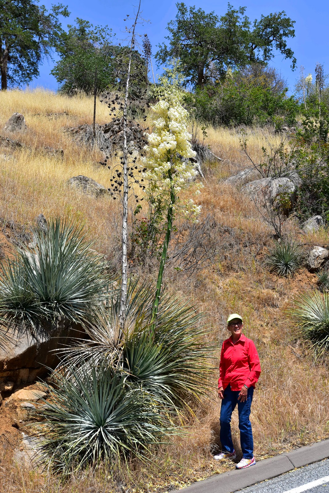
Oversized Yucca Plant
As we drove along, we came upon some gigantic yucca plants. We stopped in the visitors’ center to get advice and then we were off.  I thought that the road getting to the visitors center was curvy.  Well it was nothing compared to the next 10 miles going to the Sequoias.   There was no question when we arrived at the Sequoia grove.  These trees are magnificent.  Most of the ones we saw were anywhere from 3’ in diameter to 18’.  We had to go to the world’s largest tree, the “General Sherman”.  It is over 2200 years old, 275’ tall (nearly the length of a football field) and the diameter is between 32’ and 36’ in diameter.  Sequoias are beautiful trees.  One thing we heard is that they are mostly fire resistant.  It is hard to find any Sequoia that hasn’t been in a forest fire.  Since there was a lot of traveling involved in our visits, we were short on time on our trip into King’s Canyon.  We were able to only get an overview of the canyon.  It was very impressive even at that.
Kings Canyon

Wednesday, May 6, 2015

Yosemite Valley and Tioga Road


Day 30   May 5, 2015
Upper and Lower Yosemite Falls


Bridalveil Falls
Since Jan and I had not visited Yosemite valley together, we went over for the day.  Our day started at a local restaurant for pancakes and French toast.  We had to have fuel, didn’t we?  The drive over brought us through the tunnel that overlooked the valley just a little after sunrise.   Since the sun rises from the far end of the valley the lighting on El Capitan was from behind it, the definition of it was not good.  We will have to return to this iconic location.  As we drove through the valley, we stopped at Bridalveil Falls for a short visit.  It amazes us how steep and solid the canyon walls are, then on down the valley and back to the visitor’s center.  On the way into the visitors’ center, we came upon the Ansel Adams gallery.   I think this might have been the first time I’ve ever seen some original photos by him, most I’ve seen have been copies.  He did an “acceptable” job printing the shots.  Another place we visited was the Ahwahnee Hotel. 
Ahwahnee Hotel
This is a beautiful hotel located at the base of one of the walls of the “Valley”.  Since we had heard of the Tuolumne Meadows and the Tioga Pass section of the park, we headed that way.  Monday, May 4 was the first day that this section of road had been open for the summer.  This road, mile for mile, is one of the most beautiful roads we have ever traveled.  There was overlook that allowed us to look at the backside of “Half Dome”.  One of the pictures shows people climbing the small dome before climbing the cable to the top of “Half Dome”. 
Backside of Half Dome--enlarge and look for climbers
Driving back into the valley before we headed home, we noticed that the afternoon light had changed the whole look.  So, as we drove up and out of the valley we came back to the “Tunnel View” site that we had started our day looking off.  It was a wonderful good bye to Yosemite.

Yosemite Valley as we left

Monday, May 4, 2015

Vernal and Nevada Falls Hike


Day 29    May 4, 2015

Nothing but optimism toward our hike
Monte at Nevada
As Jan said in her text this morning to me May the fourth be with you and it was today.  This was an extremely rare day today.  I went hiking without her.  We have had a running friend who lives in San Jose that came down to go hiking with me.  Since Jan had done so many tough hikes recently, she bowed out of going with us to hike up Vernal and Nevada Falls at Yosemite.  We have found that the parks maps and trail signs can’t be trusted here in Yosemite.  To show you what I mean, today’s hike according to the park newspaper was suppose to be round trip 3.6 miles and the trail signs totaled 6.8 miles but my Garmin totaled 8.8 miles.  This is the worst park I have ever been in for accurate distances. 
Vernal Falls
To Vernal Falls we had were nicely paved trails that climbed at 12 to 14%.  When we reached the bridge at the bottom of the falls there was a fairly large crowd.   From there we climbed the Mist trail to the top of Vernal.  Calling the trail Mist was very accurate.  I had to pull out one of my Kroger weather shields (plastic bag) to protect my camera. 
Mist Rainbow Vernal
At this point the trail was mostly granite steps.  This kept the steps from being very slick.  The fellow in front of me noted that each step was about 12” up and there were a lot of them in front of us to climb.  The falls were beautiful and I could easily see why someone would slip up and step into the pool above the falls to cool off.  It was extremely inviting.  From the top of Vernal there was a nice climb to Nevada Falls. 
Nevada Falls
 
Trail to Nevada Falls
Near the bottom of Nevada there was a beautiful place to look up toward the falls it was also a good place to take in a little water.  From there the trail turned away from the falls and through a forest setting before beginning a granite path to the top.  The granite trail was extremely interesting with its switchbacks and steps to the top.  Several folks were discussing going on the top of Half Dome.  For me that was not even a consideration. 
Nevada Falls
Climbing a granite rock hanging on to cables just didn’t excite me, never mind that the park said it would have taken another 10+ miles (give or take a few miles).  Since we decided to take a loop trail to return the trail was new to us.  It was a much better trail (mainly because it was downhill). This ended up being a terrific workout and hike.
Sure we would be happy to go further